


-10%
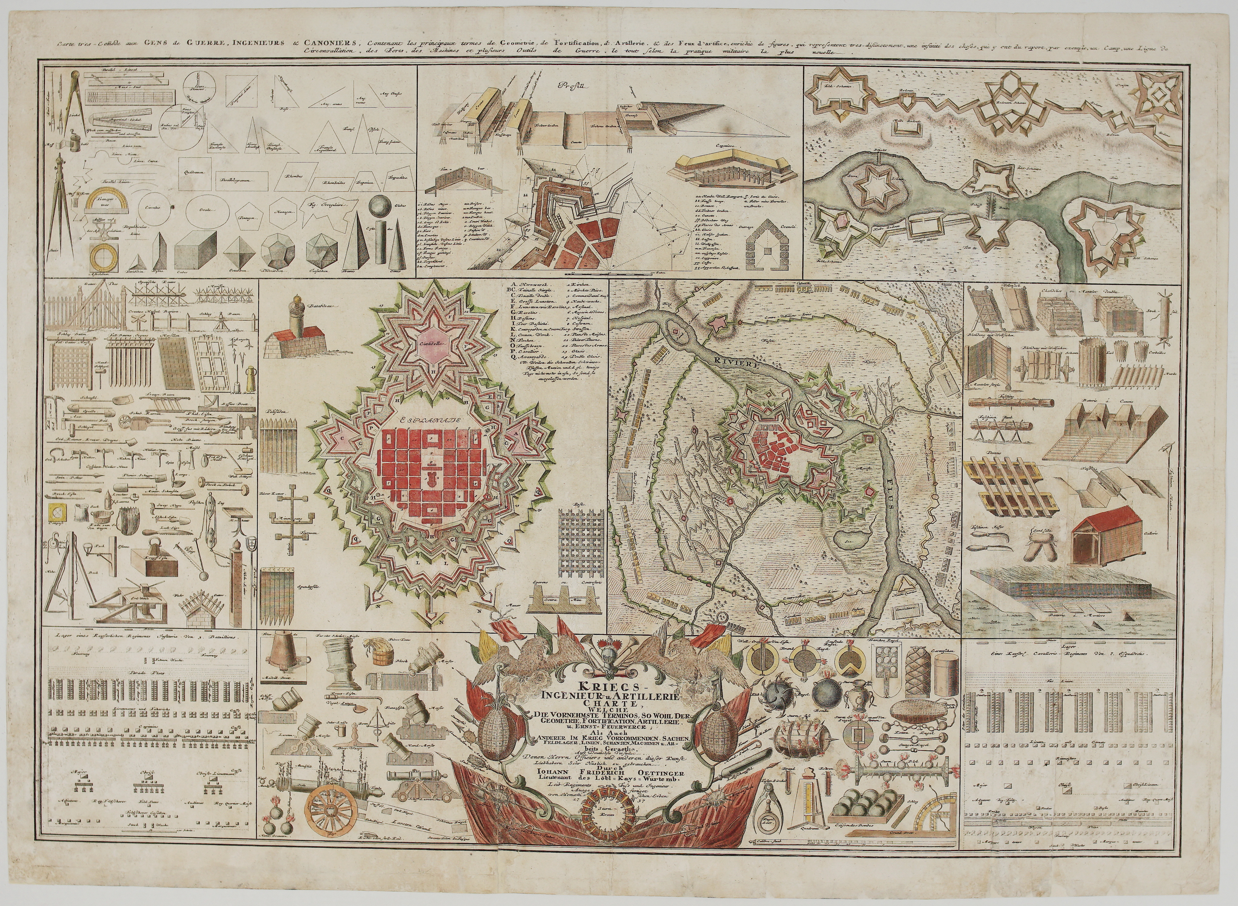
1737 – Homann Erben – Kriegs Ingenieur Artillerie Charte
$ 50.19
Available on backorder
- Title: “Kriegs-Ingenieur- u. Artillerie-Charte, welche die vornehmste Terminos, so wohl der Geometrie, Fortification, Artillerie u. Ernst-Feuerwerck als auch anderer im Krieg vorkommender Sachen…1737” & “Carte très commode aux gens de guerre, ingénieurs et canonniers : contenant les principaux termes de géométrie, de fortification, d’artillerie, et des feux d’artifice…” Description: Very rare, large and decorative copper engraving illustrating various tools and fortifications of military engineering. Created after the designs of Johann Friedrich Oettinger, this comprehensive “Military Engineer and Artillery Chart” served as a visual encyclopedia of early modern warfare. It is divided into several thematic sections: Geometry & Instruments: The top-left corner details fundamental geometric terms and shapes (circles, triangles, spheres, etc.) alongside drafting tools like compasses and protractors. Fortification & Siege Warfare: Central to the sheet are intricate plans for star-shaped fortresses and city defenses. These include diagrams of bastions, trenches, and defensive earthworks used during sieges, such as those during the War of the Spanish Succession. Artillery & Equipment: The bottom and side margins depict various highly detailed renderings of siege machinery, tools (Arbeits Geraethe), and explosive devices (Ernst-Feuerwerck) used in 18th-century combat. Topography: Detailed maps of specific fortified cities, such as Landau, are featured to illustrate actual military engineering in the field. The decorative center-bottom cartouche contains the formal title and publication information, often surrounded by motifs of banners, cannons, and armor. It includes explanations on the strategic art of besieging cities and fortifications, making it a valuable instructional tool for officers of the era. The engraving comes from Homann Erben atlas “Atlas Novus Terrarum Orbis Imperia Regna et Status Exactis Tabulis Geographice Demonstrans…”, published in Nuremberg, 1737. Cartographer: Homann Erben (1724-1780) Sheet size: 75,0 x 54,0 cm Year: 1737 Technique: copper engraving Condition: Good condition, original hand coloring, watermarked paper. Professionally restored on verso. This is an original antique map published in 1737 and NOT a modern copy or reprint On your request I will provide a Certificate of Authenticity
Related products
-17%
-19%